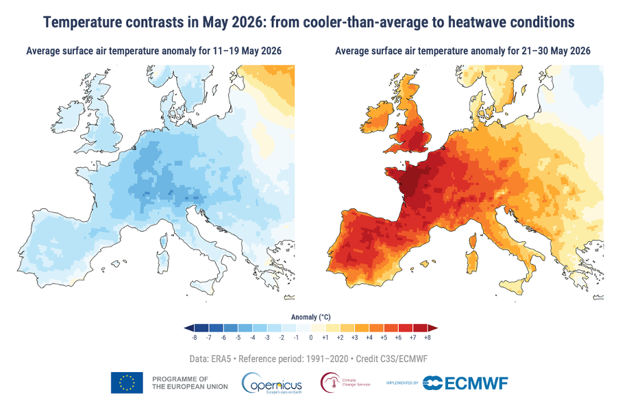
May 2026 was the second-warmest May on record, according to the latest data from the Copernicus Climate Change Service (C3S), with average global surface air temperatures reaching 15.81°C.
Only May 2024 recorded higher temperatures, the European Centre for Medium–Range Weather Forecasts (ECMWF) service noted, with temperatures for May 2026 standing at 1.42°C above pre-industrial levels.
“May 2026 was the second warmest May on record globally, extending the exceptional global warmth, with near-record temperatures in both the atmosphere and the ocean,” commented Samantha Burgess, strategic lead for climate at ECMWF.
“In Europe, an unusually early and intense heatwave demonstrates how quickly climate extremes are becoming the new normal rather than the exception.”
‘Rapid transition’
In Europe, the month saw a ‘rapid transition’ from cooler-than-average temperatures to heatwave conditions in many countries, the data showed, with temperature records broken in France, the UK, Ireland and Portugal.
As C3S noted, ‘feels-like’ temperatures reached 35°C to 40°C across large parts of the region, with the rapid change in temperature leaving ‘little time for people – or crops and ecosystems during growing season – to acclimatise to much higher temperatures.’
In addition, large parts of western, central and eastern Europe, including Italy and Spain, experienced drier-than-average conditions, while northwest continental Europe, north Scandinavia, Finland, Türkiye and the Black Sea region were wetter than normal.
On a global level, wetter-than-average regions in May 2026 included the northern and southeastern North America, regions of Asia north of Indian subcontinent and in western China, as well as parts of Brazil, southern Africa, and large parts of Australia, C3S added.
At the same time, drier than average conditions prevailed in the central United States, large parts of Central Asia, Madagascar, southwestern Australia, and much of South America.
High sea surface temperatures
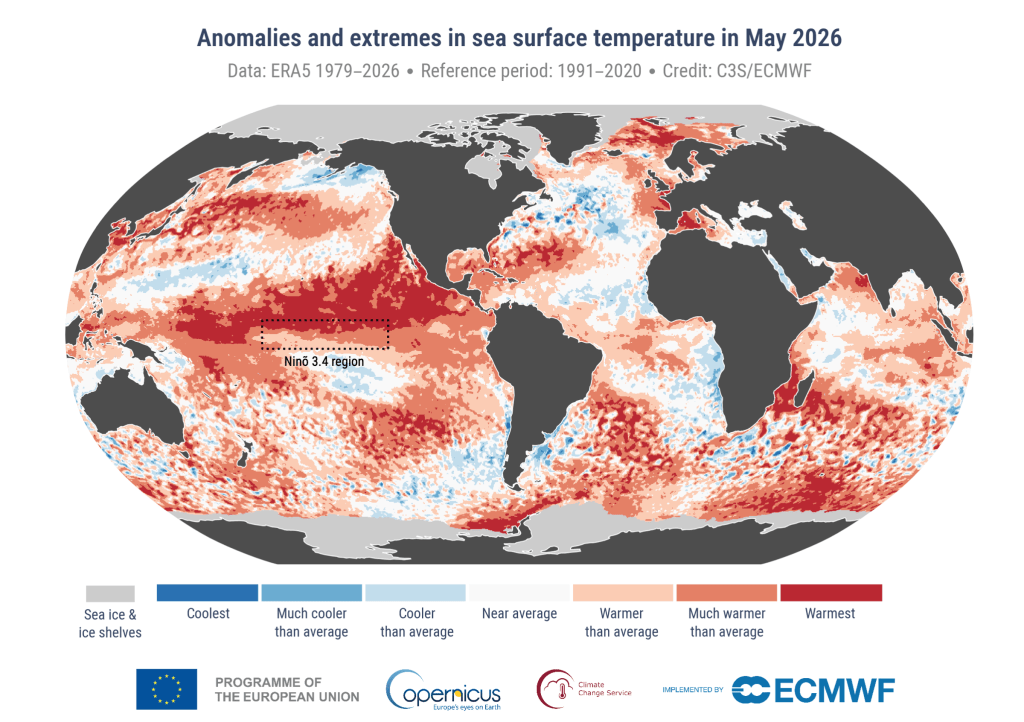
Elsewhere, ‘exceptionally high’ sea surface temperatures (SSTs) were recorded in the tropical Pacific, with the region continuing to transition towards El Niño conditions, which are expected to develop in the coming months.
At a global level, SSTs were at the second-highest level on record, with the average temperature between 60°S and 60°N reaching 20.90°C.
Sea ice levels also remained below average, with the extent of Arctic sea ice extent sitting at the fourth lowest on record for May, while Antarctic sea ice extent was around 9% below average, making it the seventh lowest May extent recorded. Read more here.